- Welcome
- News & Events
- Where to Stay
- Food, Drink & Entertainment
- How to get to Sanday
- Sanday Ranger
- Out and About
- Archaeology & History
- E-Souvenirs
- Image Gallery
- Contacts
- Links


Archaeology & History
 We can't compete with the spectacular sites of the mainland, but to the discriminating eye Sanday is the 'jewel in the crown' of Orkney?s 5,000 years of human habitation. Pool's Neolithic settlement, the mysterious Styes of Brough, Quoyness chambered cairn, and the exciting discoveries made at the Viking boat burial ? all these and more are featured in the leaflet published just this year and available through the Orkney tourist offices, in the airport , on the ferries and at various places around Sanday. Find yourself a copy, and come and see for yourselves.
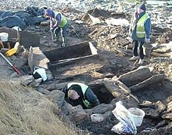
If you're fairly flexible (you need to bend or crawl on hands and knees depending on how tall you are), you can enter the amazingly well-preserved Neolithic chambered tomb at Quoyness. At Pool there was a large settlement occupied from the Neolithic period right up until the 12th century, and you can see all the layers that built up over the centuries in the cross section of the site visible from the beach below. Elsewhere there are remains from the Bronze and Iron Ages. A recent excavation at Meur (2005), the result of a storm revealing upright stones, brought to light a Bronze Age burnt mound. There are several Broch sites on the island, one on the point of Tress Ness, for example. The Vikings too have left their mark. Although there is little to see at the site of the Boat Burial at Scar, the precious remains from this burial, including a unique whalebone plaque, can be seen in the museum in Kirkwall. A Viking Rune-stone is on display at the Kettletoft Hotel in the village of Kettletoft.
 As you travel around the island look out for "farm mounds", where farm buildings are perched on a noticeable rise. These mounds are the result of the build up of debris over thousands of years of continuous habitation (examples are at Beafield in Lady, and Tofts in the North End).
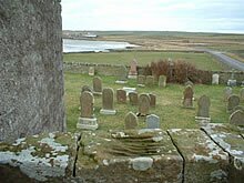
Sanday island is divided into three parishes: Cross, Burness and Lady. In the past each parish would have had its own kirk and its own school, and by the 19th century several 'break-away' chapels and kirks. This accounts for the number of manses, kirks and schoolhouses throughout the island, many of which have been converted into private houses. Now the island has a centralised school and one kirk. One extraordinary relic of past church history is the old horse-drawn hearse that resides in the "Hearsie Hoose". This was used to take coffins from the North End to the Lady Kirk. Ask one of the locals or the Ranger to show it to you. They could also show you the "Devil's clawmarks" at the top of the stairs the ruins of the Lady Kirk.
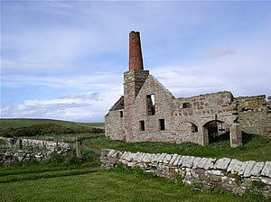
 At the south end of the island, near the Loth ferry terminal you can seen the ruins of a 19th century indudstrialised farmstead at Stove. The "New Model Farm" boasted a steam engine house, and the remains of the red-brick chimney and boiler house are still very much in evidence.
During World War One the island saw little activity, but a glance at the number of names on the War Memorial in Lady village reveals that this does not mean that the island was untouched by the conflict. The Drill Hall in Lady was where volunteers trained and drilled. It still stands but is now a private residence. At the end of the war, the German destroyer B98 broke from its tow rope and was driven ashore. The turbines and boiler still lie on the sands at the Bay of Lopness and can be easily viewed from the picnic site there.
 The Second World War had a much greater impact on the island. A dummy airfield was built on the Plain of Fidge, close to Cata Sand, and the control room for this still survives. It is known rather confusingly as 'The Brickie Hut' even though its exterior is concrete. Further north a radar station, RAF Whale Head, was constructed in 1941, with a relief radar staion a short distance away at Lettan. The coming of the radar necessitated the building of a camp at Langamay to house military personnel. Some of the facilities on the camp, a cinema, for example, were enjoyed by the locals but the effect the influx of several hundred people had on the island must have been quite something. All of these installations were in the North End ? the remains of many bunkers can be seen around the North Loch, some forming very handy storage for farmers. A new information leaflet on these Second World War sites will be published soon.
You can find a map showing some of the sites mentioned above here: (note, 3. the Isle of Sanday Knitters, no longer operates).